What is the Derogation?
The Nitrates Directive came into force in 1991. Its objective is to protect water quality from agricultural pollution and to promote the use of good farming practices. Despite this, nearly half of our rivers (47%) and a third of lakes are failing to meet their environmental quality standards for nutrients, with serious consequences for the health of Irish waters.
The Nitrates Derogation is a licence to spread more organic nitrogen per hectare on land than is routinely permitted under the Nitrates Directive. According to the text of the Directive, organic Nitrogen is livestock manure applied to the land each year, including by the animals themselves.
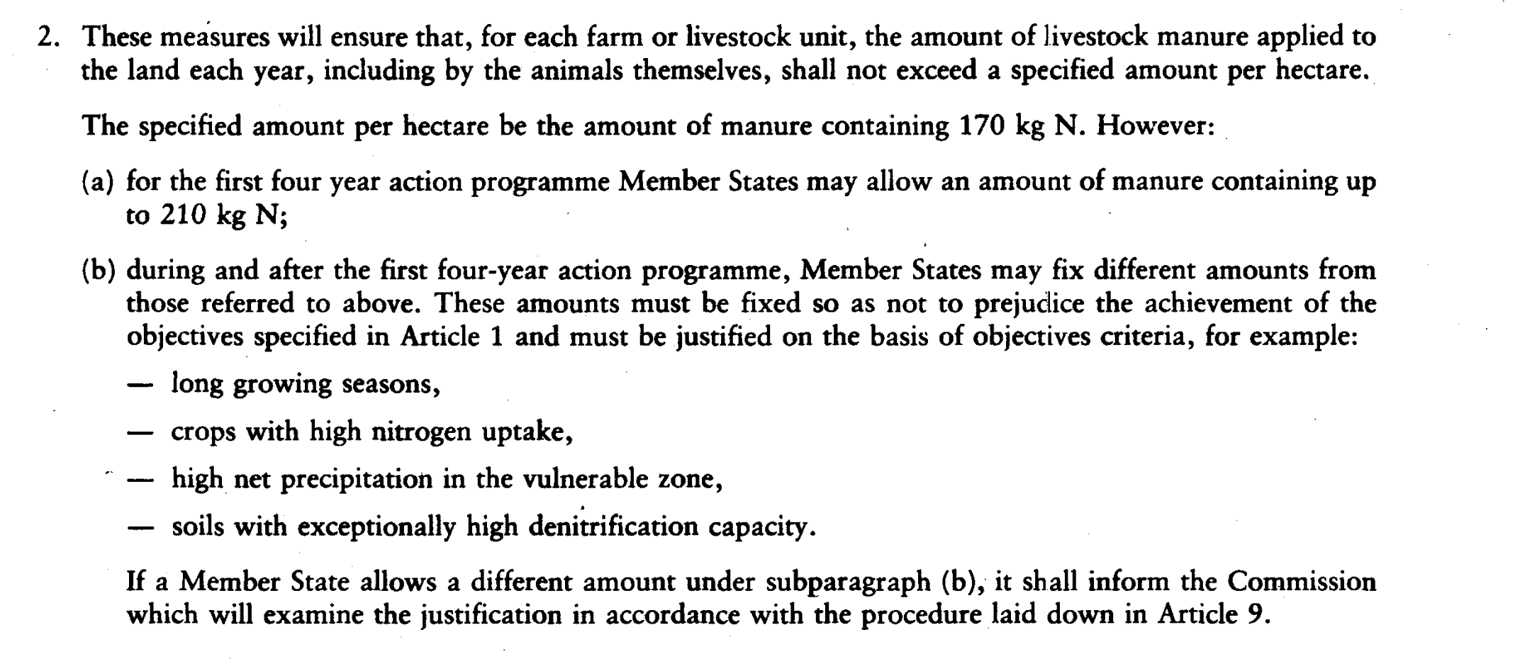
Text from Annex III of the Nitrates Directive
As a member state, Ireland applies to Europe for this every 4 years, based on the argument that we have a long growing season, our fields can absorb it, and that it will not put water quality at risk. Once granted by the European Commission to the Irish government, Irish farmers in turn apply annually to the Department of Agriculture, Food and the Marine for a derogation licence for their farms.
While the Nitrates Directive allows for the granting of derogations, it does so on the proviso that the derogation does not undermine the objective of that Directive, which is to reduce and prevent water pollution as a result of agriculture. Under normal circumstances, a landowner is not allowed to apply more than 170 kilograms of organic nitrogen per hectare per year on their land, however if you are operating under a derogation licence you can lawfully spread up to 250 kilograms of organic nitrogen per hectare per year on your land. Landowners farming under a derogation are subject to stricter regulation, such as an obligation to use low emission slurry spreading and demonstrating sufficient capacity for slurry storage.
What is happening with the Derogation?
When Ireland was granted a derogation in April of 2022, the Commission put in a condition
that an interim water quality review be carried out in 2023, and that in areas where water
quality criteria, determined by the Commission, have not been achieved then additional
measures must be put in place by January 2024. This interim water quality report was
conducted by the EPA and is published here. There were four pollution criteria included in
the derogation decision, two of which are based on the nitrate concentrations in water, and
two on eutrophication. The eutrophication assessment is based on the nutrient status- that
is, if nitrate and phosphate are elevated, and on biological indicators such as plants and
invertebrates. The EPA laid out their methodology for monitoring water quality and nutrient
status in this document.
What is the EPA ‘Red Map’?
Based on these criteria, determined from a particular sampling network, the EPA produced a
map, the ‘Red Map’, indicating where additional measures are required. Anywhere within the
Red Area is deemed to need additional measures according to the derogation decision,
including a reduction in the maximum amount of nitrogen that can be spread on derogation
farms, reduced from 250 kilograms of nitrogen per hectare per year, to 220 kilograms of
nitrogen per hectare per year.
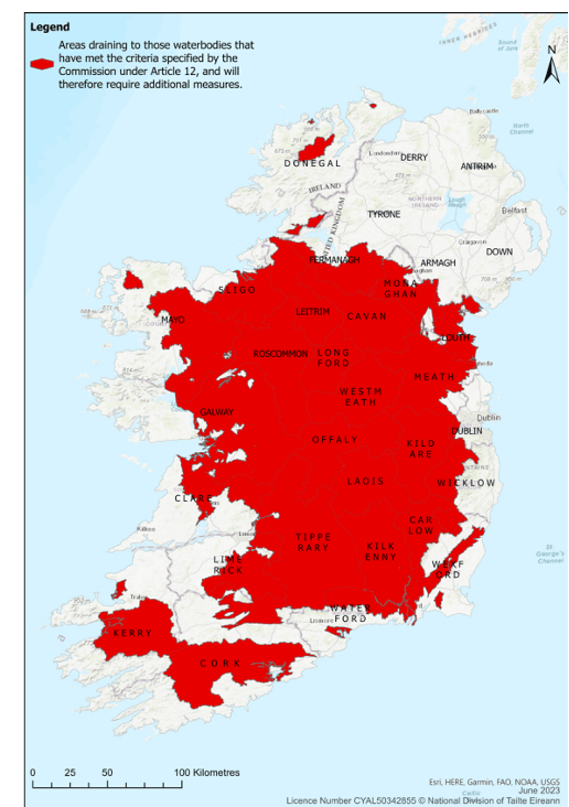
EPA ‘Red Map’
Why does the map look strange?
You may logically ask why the map is not coloured in some areas which, based on previous
EPA water quality reports, are clearly in need of additional measures when it comes to water
quality. For example, the Slaney river was previously reported to have more than 50%
excess nitrogen, yet a large part of its catchment doesn’t seem to require additional
measures. How does this make sense?
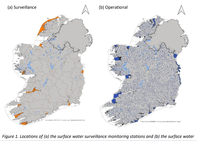
The reason is largely due to the sampling network used. The EPA have a very extensive
sampling network which they use for their Water Framework Directive monitoring. However,
for the purposes of the Nitrates Directive the EPA are only required to use a subset of this
sampling network- as laid out in Article 12 of the Nitrates Directive. This is what the EPA are
mandated to do. The maps below highlight the difference between the sampling networks.
The surveillance monitoring network, which was used to create the Red Map, is used for
reporting for the Nitrates Directive, and represents a proportion of representative
waterbodies, sampled frequently. The Operational Network is sampled less frequently but is
more extensive.
In a nutshell, some of the areas in the Red Map are not included solely because there was
no representative sampling point for that area.
Does this mean the EPA data is invalid?
In a word, no. The EPA consistently produce high quality data, based on robust
water/catchment science which we can fully depend on. The EPA themselves acknowledge
that the dataset they are obliged to use for the purposes of reporting on the Nitrates
Directive is more limited spatially than what they use for the Water Framework Directive
reporting, as a result of the former being a much older Directive, and not fully reflecting the
more modern catchment-based approach. The below map, Map 9 from their water quality
report, represents their most comprehensive data, where they clearly overlay where
agricultural measures need to be targeted, based on their full operational data set.
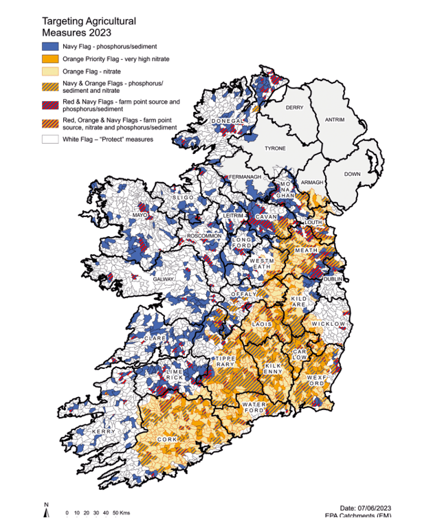
EPA Map 9
Where do we go from here?
Views have been expressed within the agri-media that reducing the derogation limit within
those Red areas would achieve nothing for water quality. This is categorically untrue, any
reduction in the load of nitrogen onto catchments with excess nitrogen will benefit water
quality, with variability in efficacy based on local factors. However, for the best outcomes
water quality measures should be targeted as indicated on the map above, in Map 9.
It is now up to the Irish Government to chart a path forward, based on the results and the
requirements of the Commission Decision. A critical point to note is that the Irish
Government is fully entitled to rely on additional information, so there is nothing stopping
them from implementing additional measures, and additional reductions in nitrate limits, in
the necessary areas as indicated by the EPA in their more comprehensive data. That is,
while Ireland is legally required by the derogation decision to reduce the derogation limit in
those Red areas, they are free to propose additional measures both within and outside of
those areas if they believe this will lead to improvements in water quality, for example more
stringent nutrient management plans, or changes to manure spreading.
So, for those attesting that the EPA Red Map is ‘nonsensical’ and that the Commission are
forcing Ireland to only use this data, the reality is that Irish Government can choose what additional data to rely on, to complement what the EPA have already produced to fulfil the
requirement of the derogation decision. More comprehensive data is available from the EPA,
as outlined above, and it could and should be used in charting a way forward for this.
Logically, based on the more detailed monitoring by the EPA, and recent nitrate pollution
trends, large swathes of Cork, Waterford and Wexford should also be included in the Red
Map. Additionally, there are areas up north, for example in Roscommon, which according to
the EPA’s best science, won’t benefit as much from nitrate reduction measures, as
phosphate is the issue in many of these areas. It is now up to the Irish Government to
present that argument to the Commision, in a well-formulated plan, based on the full picture
provided by all of the data produced by the EPA.
Whatever path is chosen, taking action to tackle water quality is no longer optional, and the
derogation decision is legally binding. Any delay, or lack of compliance will do nothing to
further Ireland’s chances of securing a future derogation, if that is what the Irish
Government intends to do in 2026. We’ve reached a critical point in tackling water quality in
Ireland, and given recent trends over the past decade we need ambitious and far-reaching
actions to address water pollution.